America’s Most Scenic Drives – Driving 89A in Arizona between the old mining town Jerome and Old Town Cottonwood via historic Clarkdale.
This is the companion guide to our YouTube video with the same title.
About this series – America’s Most Scenic Drives
Americans love the lure of the open road! It’s about enjoying the freedom and mobility that the automobile brings us — and that’s what this series is all about.
Through each of our 49 lower states—from Washington to Florida and Maine to California, this series serves as your guide to the most breathtaking, intriguing, dramatic, and eye-pleasing stretches of road in the U.S.
There are 3 parts to this series:
- Video – glorious 4K film of each scenic drive is available on Youtube. Just follow the link above. Each drive is recorded from start to finish so you can experience the complete drive.
- Map – each route is recorded and shown on Google Maps so you can get directions, follow along, and/or plan your road trip based on your interests and budget.
- Website – you are reading the companion guide to one of our scenic drive videos! Every video has a link to a web page with more information about the drive. Read about the history, attractions, hiking trails, my recommendations for camping and lodging, and many other useful bits of information.
Sit back and relax as America’s Most Scenic Drives take you on an unforgettable journey to America’s most spectacular scenic landscapes, natural wonders, and man-made marvels.
Recommended stops along this route
- Jerome State Historic Park
- Downtown Jerome
- Gold King Mine & Ghost Town
- Scenic Overlook along 89A
- Downtown Clarkdale
- Verde Canyon Railroad
- Tuzigoot National Monument
- Old Town Cottonwood
- Dead Horse Ranch State Park
- Blazin’ M Ranch
About Jerome State Historic Park
This park reveals the story of the city of Jerome inside the historic Douglas Mansion. The Douglas Mansion has been a landmark in Jerome since 1916 when James S. Douglas built it on the hill just above his Little Daisy Mine.

The museum features photographs, artifacts, and minerals in addition to a video presentation and a 3-D model of the town with its underground mines.

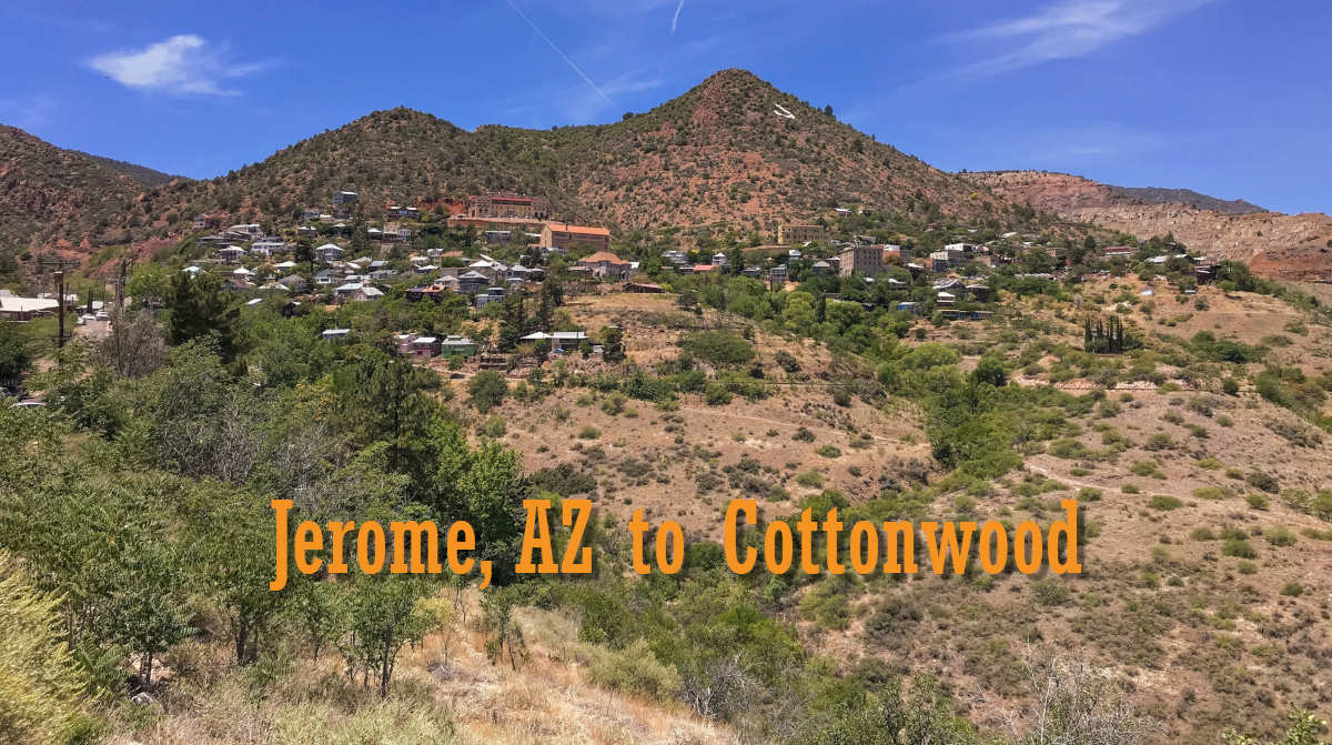
About Jerome, Arizona
Jerome, incorporated in 1899, is located approximately 100 miles north of Phoenix and 45 miles southwest of Flagstaff on State Highway 89A.

The town sits perched on the side of scenic Cleopatra Hill at an elevation of over 5,000 feet in the Black Hills of Arizona.
In 1876, the area was known for rich ore deposits, and mining claims (tented camps) were scattered up and down the hillside. These claims were purchased in 1882 by the United Verde Company, and the area was named Jerome after Eugene Jerome, a major financier of the company. Senator William Clark of Montana purchased the company in 1883.
By mid-1920 the population had grown to almost 15,000 before it began to decline. When the mines shut down in the 1950s, the population was below 100. It was then the town became known as a ghost town.
Walking down Main Street is like taking a step back in time. Remnants of the Red Light District, Company Hill, old hotels, and saloons still exist.
Today’s Jerome is a bustling artistic community with artists, craftspeople, musicians, writers, hermits, business owners, and historians! Together, they form a peaceful, colorful, thriving community built on a rich foundation of history, art, and ghost lore, and the town has become a major attraction for visitors to Arizona.
A major attraction is a fantastic view from Jerome, which overlooks the Verde Valley and the spectacular red rock cliffs of the Mogollon Rim, capped by the 13,000-foot San Francisco Peaks 50 miles to the north.
A few things to know when visiting Jerome
Parking – Free and Paid parking is available but it is tricky to figure out when to pay or not. Before visiting, please read – Jerome Parking Information

Shuttle – getting around Jerome is challenging for anyone who struggles with walking. The streets are steep and uneven. On busy weekends, the lack of parking creates additional problems. Fortunately, a free shuttle is available on weekends and holidays. Please read – Jerome Shuttle Information
Ghost Tours – A must-do in Jerome! Please read – https://jeromeghosttours.com/
Tourist Information – In a small downtown building manned by volunteers who will help answer your questions (when they are available).

Recommended hotels in Jerome
I like any one of the 3 downtown hotels because of their history and central locations.
- The Connor Hotel – Traditional Western bar vibes with a colorful history.
- The Clinkscale – A more upscale boutique look and feel with a highly-rated restaurant.
- Grand Hotel – A hospital converted into a modern hotel with an interesting history of haunting experiences. On top of the hill and further away from downtown, so consider the steepness and location when booking.
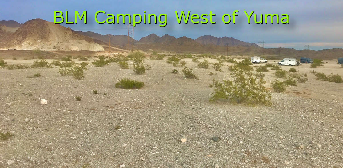
Recommended FREE camping near Jerome
Head to Prescott National Forest about 7 curvy miles above Jerome! Look for the Mingus Mountain Recreation Area turn. FREE camping is available along the forest roads to the left and to the right.

FR106 (only up to the red cattle gate) is my favorite but also try FR413. The forest roads are bumpy but doable in any type of vehicle.
Strong Verizon service at most sites.
Recommended USFS Campground camping near Jerome
Potato Patch Campground on FR106, a short distance from 89A. Strong Verizon service.
- 28 campsites with picnic tables, grills, and fire pits (A-Loop)
- 3 accessible campsites and 2 accessible toilets (A-Loop)
- 1 double site (A-Loop)
- 12 campsites with picnic tables and electrical hookups for RVs (B-Loop)
- 2 accessible campsites and 1 accessible toilet ( B-Loop)
- Each site in A-Loop has a 40-foot paved driveway
- Composting toilets
- Drinking water is available for use on-site, but not for filling RV water tanks
- Garbage service
Please read – Potato Patch Campground Information
Commercial Campgrounds near Jerome
None – for a central location along this route and beautiful views, I recommend Rainspirit RV Resort in Clarkdale.

To learn more about Jerome
Please visit
Gold King Mine and Ghost Town
The location used to be a mining town called Hayes. Today it exists as a relic of the past – in 1890 they drilled a mine shaft looking for copper and they found gold!
Unfortunately, the gold ran out and the mine was closed. Today you can visit the historic location and see the mine shaft (you cannot enter it), as well as a large display of “mine junk” – rustic buildings and machinery.
This place is not for everyone. In short, it is a junkyard but interesting nonetheless. I suggest you read a few reviews before deciding to visit.
Please visit the Gold King Mine website
About the Scenic Overlook along 89A
The first of several pullouts above Jerome, this overlook provides a limited but stunning view of 89A, the Verde Valley, and Sedona in the distance.

About Clarkdale, Arizona
The company town of Clarkdale was built in 1912 at the direction of Senator William Clark to house the employees of the United Verde Copper Company.

At the time of its inception, Clarkdale was designed with four distinct neighborhoods based on a class structure:
- Upper Town – with its wide boulevards, large lots, and a great assortment of home designs, it was home to primarily white-collar employees.
- Lower Town – with its identical neoclassical bungalows, this was where the blue-collar employees lived.
- Patio Park – a neighborhood created for immigrant Mexican laborers.
- Rio Vista – an area near the Verde River where people built their own homes on land rented from the company.
Ahead of its time, Clarkdale boasted underground utilities, sewers, paved streets, stylish homes, and a thriving commercial center.

To learn more about Clarkdale, please visit – https://www.clarkdale.az.gov/35/Visiting
About the Verde Canyon Railroad
Known as Arizona’s longest-running nature show, this 4-hour rail journey between Clarkdale and Perkinsville traverses the remote wilderness of the Verde Canyon.

Experience towering, red rock pinnacles, clean, green waters, Indian ruins, tunnels, trestles, and clear, azure desert skies.
Visit the Verde Canyon Railroad website
About Tuzigoot National Monument
Tuzigoot (Apache for “crooked water”) is the remnant of a Southern Sinagua village built between 1000 and 1400.


It stretches along the summit of a long ridge rising 120 feet above the Verde Valley.

Please visit – https://www.nps.gov/tuzi/index.htm
Recommended FREE camping near Clarkdale
I love the area along Sycamore Canyon Road. Once you enter Coconino National Forest, there are many sites with great views of Jerome and the nearby mountains.

From Clarkdale, take the road to Tuzigoot then turn left on Sycamore Canyon Road. Continue on the paved road until it crosses a cattle guard. You are now in Coconino NF. Camping is available along FR9515 and FR258.
Verizon signal is strong in this area.
Commercial Campgrounds near Clarkdale
See the description above for Rainspirit RV Resort in Clarkdale.
About Cottonwood, Arizona
William Clark and Jimmy Douglas developed the mining community Clemenceau in 1917. Located near the intersection of Willard Street and Mingus Avenue, Clemenceau was a complete company town with thousands of residents, a school, and other community facilities.
Old Town Cottonwood became a haven for those seeking to be free from the prejudice and regulation of nearby company towns. Main Street was created in 1908 when Charles Stemmer and Alonzo Mason used a mule team to pull and drag through the brush.

The Clemenceau smelter closed in 1937 and most residents then left the area. When Cottonwood was incorporated in 1960, Clemenceau was included in its boundaries.
Recommended hotels in Old Town, Cottonwood
I like these two hotels because of their central locations in Old Town and their many positive reviews.
- Tavern Hotel – A block from shopping and dining on Main Street, this upscale hotel is located in a renovated circa-1925 building!
- Iron Horse Inn – On Main Street and nearest to the action, this is a boutique hotel where each room is designed uniquely!


To learn more about Cottonwood, please visit –
Dead Horse Ranch State Park
Ideal for camping (campgrounds and cabins), mountain biking in the Coconino National Forest, hiking along the Verde River, canoeing, picnicking, and fishing!

I like the trails around the three lagoons. It is a bird lover’s haven.

To learn more about Dead Horse Ranch State Park, please visit – https://azstateparks.com/dead-horse/
About Blazin’ M Ranch
Established at the turn of the 20th century, the Mabery Ranch is an authentically replicated Western town offering dinner theater and other activities.
Please visit – https://blazinm.com/
Route Map
Below is a Google map of the route shown in my video. Please use this map to search for and locate points of interest such as restaurants, hotels, etc.