This is a complete guide to FREE dispersed camping in Routt National Forest near Steamboat Springs, CO. There are free camping opportunities in many parts of the National Forest – this guide focuses on the dispersed camping areas within an easy, short drive from Downtown.
In this guide, you will find maps with directions, updates on road conditions, locations of most campsites, and availability of amenities such as cell coverage, water, and toilets.
About Routt National Forest near Steamboat Springs, CO
The Steamboat Springs National Forest area is east and north of Steamboat Springs, CO. It is managed by the Hahns Peak/Bears Ears Ranger District with a Ranger Station/Visitor Center in the town of Steamboat Springs. Recreation sites along Buffalo Pass and Rabbit Ears Pass are located within this area including the popular waterfall hike, Fish Creek Falls.
The area lies against the western ridge of the Continental Divide and the Routt National Forest. Multiple wilderness areas are nearby. The area is bountiful with recreation opportunities such as mountain biking, hiking, camping, and fishing, as well as winter sports such as skiing and snowmobiling.
Routt National Forest – Hahns Peak/Bears Ears Ranger District website
925 Weiss Drive
Steamboat Springs, CO 80487-9315
Phone: (970) 870-2299
Maps and Directions
I highly recommend the Avenza Maps App!
Download Routt NF – Yampa Ranger District – MVUM
Campground Camping within the Hahns Peak/Bears Ears Ranger District
- Dry Lake Campground
- Dumont Lake Campground
- Granite Campground
- Meadows Campground – easiest and fastest to Downtown
- Summit Lake Campground
Recommended FREE Camping Areas nearest to Downtown Steamboat Springs
On Routt NF lands, you must camp within 300 feet of officially designated routes, and only on existing spur roads. Please respect private property and other areas that are closed to camping.
Dispersed camping is allowed on Routt NF land for a period not to exceed 14 days within a 30-consecutive-day period. The 30-day period begins when a camper initially occupies a specific location on public lands. The 14-day limit may be reached either through a number of separate visits or through 14 days of continuous overnight occupation during the 30-day period.
After the 14th day of occupation, the camper must leave the National Forest until the 31st day since the initial occupation.
Regarding potable water and toilets – there are toilets Downtown, and at the Ranger office.
Water is available in Town behind the Rodeo complex near the beach volleyball courts (see map).
While there are other areas suitable for dispersed camping near Steamboat Springs, I recommend the US 40 corridor. Along this stretch, there are 5 suitable camping roads depending on your vehicle’s capabilities. See Map:
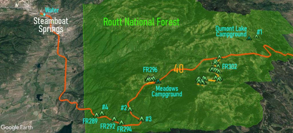
Here are my recommendations – in distance order from Steamboat Springs:
- FR289, FR292, and FR294 – these are large turnouts hidden from the highway
- FR296
- FR302 – my favorite road
I will mention a few secret spots for single SUVs, vans, or smaller RVs. These are shown on my map:
- #2 – a site or two in the trees but Verizon has a weak signal here.
- FR298.1A – #3 a small site to the left uphill of the entrance,
- FR315 – #1 past the Dumont Lake campground and trail parking on the other side of the “no camping” zone sign – this is a legal site with easy access to the paved road.
- FR313 – not shown on my map but just east of FR296 – two or three small sites. Verizon’s service is spotty.
FR289, FR292, and FR294 (Turnouts)
On the south side of US 40, these forest roads and short turnouts (half circles) have easy access to US 40.
I do not consider these my favorites because the roads are narrow and you park along the forest road – with a complete lack of privacy. If you don’t mind, then any rig can fit into these sites if there’s room.
I recommend you drive into each of these four half-circle roads and pick a spot you like. Most campers use these spots for overnight stays only, but it is up to you!
Good Verizon signal
FR296
On the north side of US 40, this is a popular, bumpy road with several (often not level) sites suitable for any type of RV (depending on availability).
The road is generally very rutted, especially after the downhill starts. Most folks camp before the downhill stretch!
Most of the popular sites are in sight of the highway with road noise until late at night. If you can handle the bad road then you can drive a short distance up the mountain for more privacy.
Spotty Verizon signal
FR302
I recommend this area for dispersed camping near Steamboat Springs! Yes, it is a bit further away from Downtown (30-40 mins) but the scenery is marvelous!
FR302 is a decent dirt road that leads 3.3 miles up to a summit with radio/TV towers. Dispersed camping is available all the way including at the top – about 24 sites in total.
Most sites are large and easy to navigate but a few are tricky when everything else is full. You can turn around at the 1.3-mile mark and in the loop at the summit but most larger rigs do not venture that high. I’ve seen 40′ rigs at the 2.7-mile mark but further up it gets steeper (still doable for most vans and smaller trailers).
Good Verizon signal

