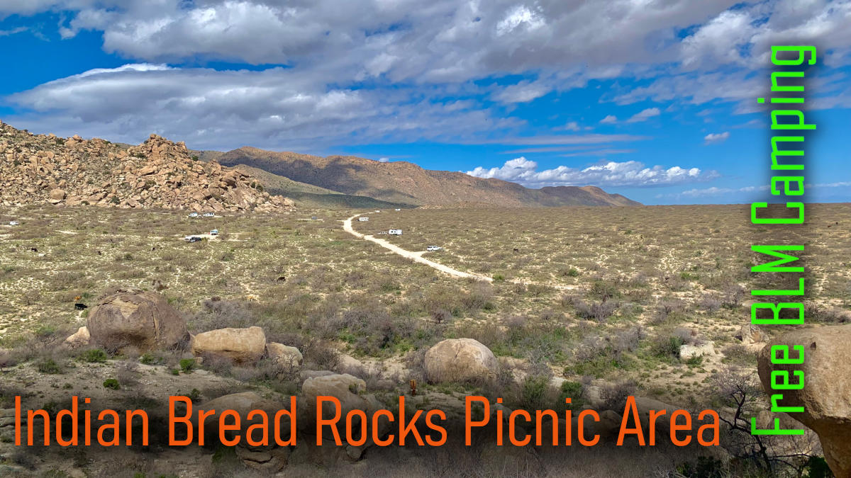
Free Camping at Indian Bread Rocks near Bowie, AZ
Welcome to our guide for FREE camping on BLM land south of Bowie in Southern Arizona. The location is called Indian Bread Rocks Recreation Area, and the land surrounding the picnic area is a wonderful place to camp for a couple of weeks.
In this guide, we provide maps with directions, updates on road conditions, locations of most campsites, and availability of amenities such as cell coverage, water, and toilets.

Our Experience
It is a great place to camp FREE for a night or 14 nights. About half the sites were taken during our visit, and everyone was pleasant and respectful. The campsites were clean and we saw no trash anywhere.
Most of the sites are private but the larger sites attract a crowd! Our site was small but peaceful.
Cattle were everywhere! Fortunately, they were mellow and did not cause any concern! We heard coyotes at night.

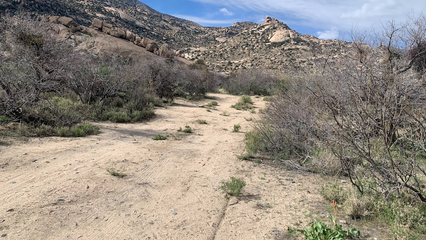
We enjoyed walking up and down Happy Camp Canyon Road and scrambling on the huge boulders behind the camp area. The views were outstanding.
Sightseeing
There are plenty of attractions within an hour’s drive. We went wine-tasting in Wilcox, soaked in the hot springs of Hot Well Dunes Recreation Area, and hiked to Apache Spring (the site of many historical conflicts with the Apache Nation) and Fort Bowie National Historic Site.
It is possible to visit Fort Bowie, Chiricahua National Monument, and the wineries in one long day, however, we recommend planning an overnight stay in or near Chiricahua to fully appreciate its beauty.


Cell and TV
Our Verizon service worked well but we did not receive any TV channels. We do not watch much TV anyway.
Water and Sewer
We opted to get drinking water from a vending machine in Downtown Wilcox at 25 cents a gallon. Around town, several vending machines are outside ACE Hardware, Family Dollar, Safeway, etc.

We filled our water bottles for free at the Historic Railroad Avenue Park.

The dump station at Love’s in Wilcox is very convenient at $10 (or $7.50 with the App). We also saw a dump station at TA Travel Center.
About Indian Bread Rocks and BLM land
Indian Bread Rocks Picnic Area is the access point to the Dos Cabezas Mountains Wilderness – number 46 on the Arizona Wilderness Areas Map. The Dos Cabezas Mountains Wilderness consists of 11,700 acres and lies 20 miles east of Willcox and 7 miles south of Bowie, Arizona in Cochise County.

Indian Bread Rocks Picnic Area is managed by:
- Safford BLM Field Office
- Address – 711 14th Ave. Safford, AZ 85546
- Phone – (928) 348-4400
Maps and Directions
We highly recommend the Avenza Maps App!
Unfortunately, there are no maps for this area and we suggest you use our Google Map for directions.
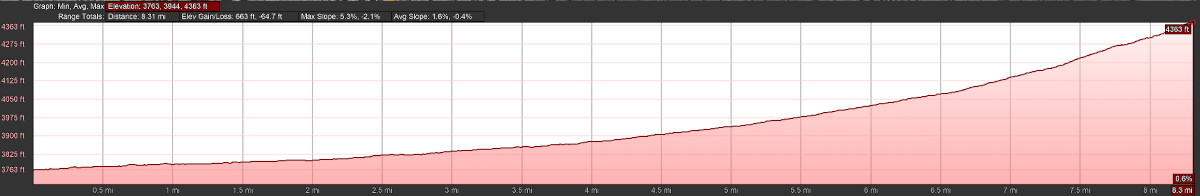
Take Apache Pass Road south from Bowie, then after 4 miles turn right on Happy Camp Canyon Rd (dirt road in good condition). The drive takes about 15 minutes.
Once on Happy Camp Rd, the first campsites appear after 2.5 miles, the picnic area at 3.17 miles and the road ends after 4.3 miles. Yes, you CAN turn a large trailer around at the end of the road, but it gets a bit rough near the end!
The road profile from Bowie to the last campsite shows a steady but gentle climb. A 4WD vehicle is not required unless you want to reach a few remote sites. We recommend good tires for grip and protection against sharp rocks in some areas.
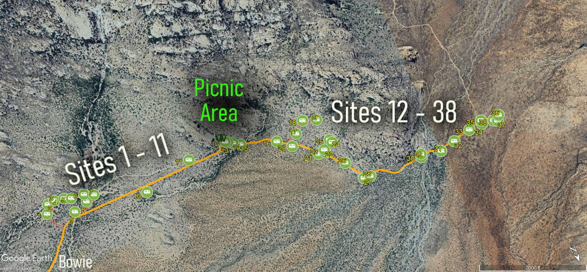
The Indian Bread Rocks Picnic Area
The Picnic area is at the center of the east and west camping areas along Happy Camp Canyon Road. You cannot camp inside the picnic area, but camping starts next door!
There is a clean drop toilet and a few picnic tables but not much else!

There are no designated camping sites. The rule is to use existing clearings and to avoid creating new ones. In total, there are roughly 38 spots that can fit about 50 vehicles when full but 20-30 campers are about average.
Please Note:
Dispersed camping is allowed for a period not to exceed 14 days within a 28-consecutive-day period. The 28-day period begins when a camper initially occupies a specific location. The 14-day limit may be reached through several separate visits or 14 days of continuous overnight occupation during the 28 days.
After the 14th day of occupation, the camper must move outside of a 25-mile radius of the previous location until the 29th day of the initial occupation.
Camping near the Indian Bread Rocks Recreation Area
To simplify this guide, we number the camping sites from 1 to 38. Our numbering system is unofficial and not to be used elsewhere.
There are roughly 11 sites before you reach the picnic area and 27 sites after. In general, sites 1-11 are not as popular as sites 12 – 38 except for site 10, which is very popular.
Sites 1 – 11
This is the quiet side! Most folks want to camp on the other side of the picnic area!
The Google Earth image below shows that sites 1 – 9 are located near a wash, meaning the area is prone to flooding. As a result, the approach roads can be sandy so we suggest stopping and taking your time to ensure you will not get stuck as you look for sites. This is why the roads are marked in red in our image.
This area is very private and you can hide even a large Class A there!
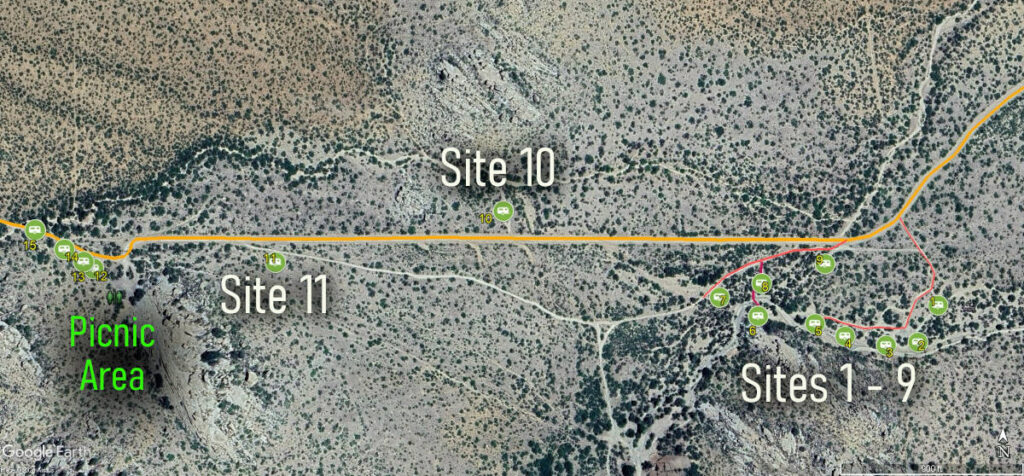


Site 10 is the prize site especially if you have a large vehicle. It is a big site and you will most likely share it with other campers. Easy and fast access to Bowie from this site.

Site 11 is a small pullout for cars, vans, or tents.

Sites 12 – 38
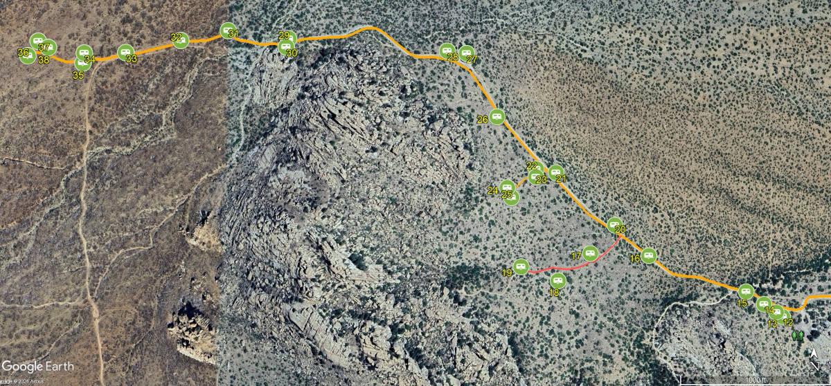
This is the busier side! We like to think of this section as two areas:
- Sites 12 to 28 are the most popular because most vehicles can reach these sites without issues.
- Sites 29 – 38 have a short rocky section that requires good tire thread to avoid punctures. There is also a shallow dip to consider if your vehicle is very long and low.
A 4WD vehicle is not required for most sites but high clearance is recommended if you aim for a more secluded site.
Most sites are very uneven and you must be creative to level your vehicle! Bring plenty of blocks.
Sites 12 – 28
Sites 12 to 14 are adjacent to the picnic area and while not private, these sites fill fast because they are large and the toilet is nearby!

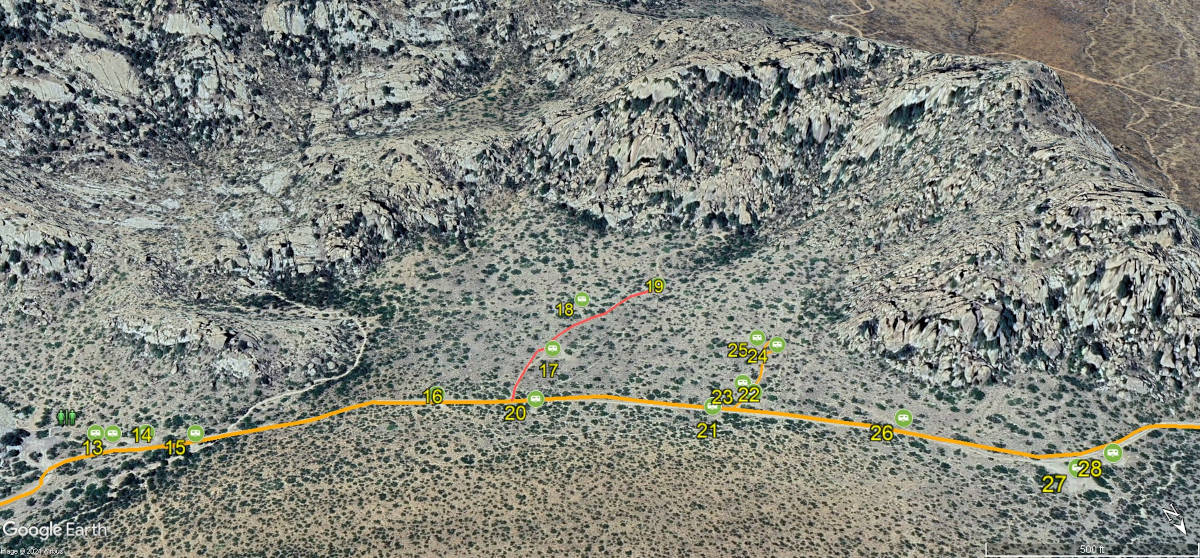
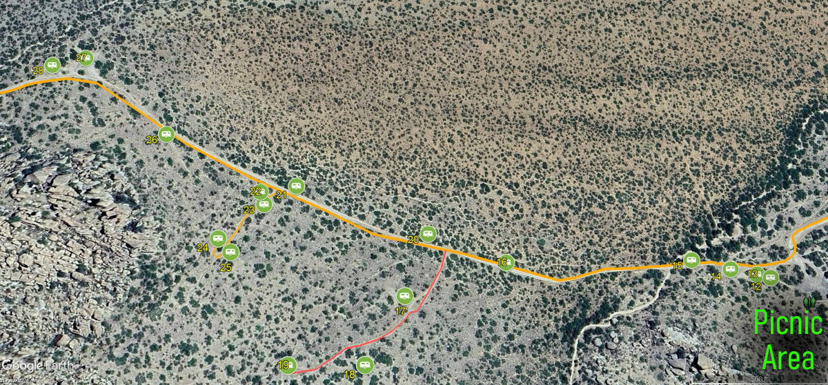
Sites 15, 16, 20, and 21 are on the right and work best for vehicles under 25 feet.

Sites 17 to 19 are to the left along a very rutted road (shown in red on our map). Do not turn before taking a look.


Sites 22 to 25 are also to the left and while the road is in a better condition, it is steeper. These sites are large with good views and are very popular despite being very uneven.

Site 26 on the left is small and suitable for a car or van.
On top of the hill, sites 27 and 28 are desirable spots with great views but you will not be alone! This is also where many folks turn around so you get more traffic at those sites.

Sites 29 – 38
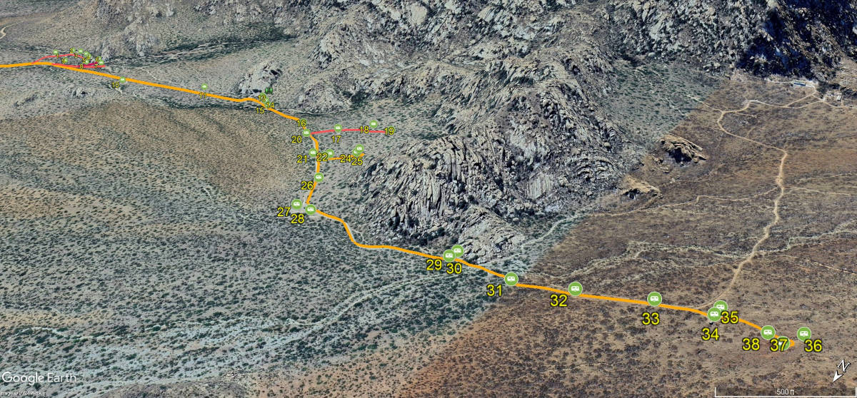
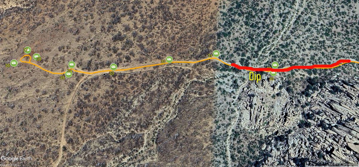
If you are looking for seclusion, continue up the slight hill where you will find nice large sites with wonderful views. Most vehicles can make it; be mindful of a short, rocky stretch through a wash that may cut a tire if you drive too fast.

The dip should not be a problem unless you are in a large class A but check it out before committing.


The road ends in a large open space where you can turn around in any sized vehicle.