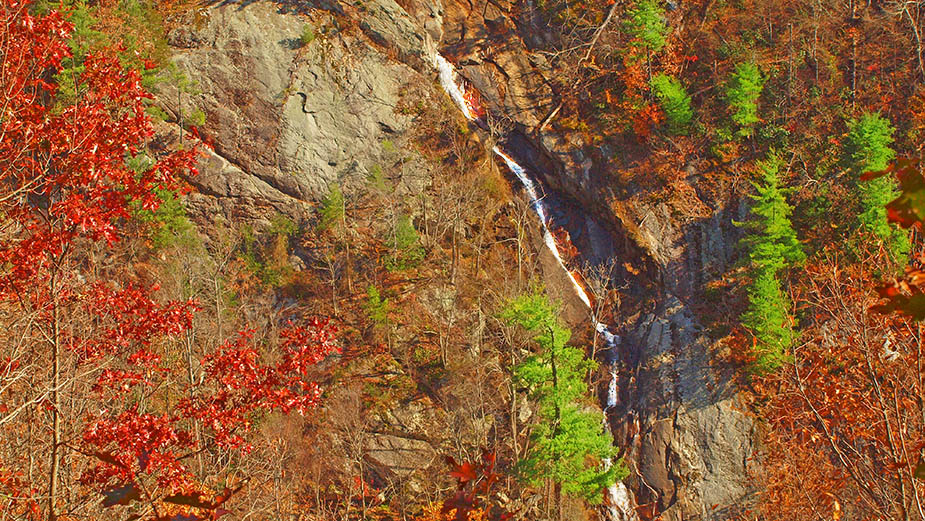
Bent Mountain Falls is one of the least-crowded waterfalls in Virginia, hidden deep within the rugged landscape of Bottom Creek Gorge Preserve. It is the second-highest waterfall in Virginia, with a dramatic 200-foot drop, peaceful forest trails, and sweeping Appalachian views.
Unlike many popular waterfall hikes, Bent Mountain Falls feels remote and wild. There’s no short walk to the base, no crowded overlook, and no paved trail. Instead, you’ll find a peaceful backcountry experience that rewards hikers with sweeping views of the gorge and a distant but powerful look at the falls.
This guide covers everything you need to know before hiking Bent Mountain Falls, including directions, trail details, difficulty level, best time to visit, and tips to make the most of your experience.
📍 Where Is Bent Mountain Falls?
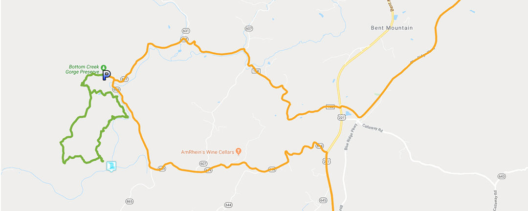
Parking Location: 37.133, -80.18232
Bottom Creek Gorge Preserve
Bent Mountain, Virginia
Directions
Make your way to Bottom Creek Lane (SR-637) and look for the bridge where the road crosses Bottom Creek. Turn west on the unpaved road for a short distance until you reach a gate. Do not block the gate when parking!
The preserve sits just south of Roanoke and is easily accessible by car, yet feels completely removed from civilization once you’re on the trail.
📌 Pro Tip: Cell service is limited in the area. Download maps ahead of time.
🗺️ Trail Overview & Hiking Details
Trail Type: Loop (or out and back)
Distance: ~4.8 miles round-trip
Difficulty: Moderate
Elevation Gain: ~900 feet
Time: 2–3 hours
Best Time: Spring and Fall
Dogs: ❌ No (dogs not permitted)
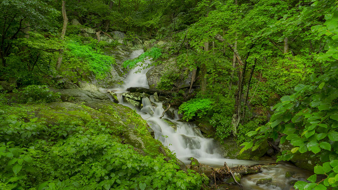
This hike follows a scenic loop through hardwood forest and along steep gorge terrain with creek access before reaching a viewpoint overlooking Bent Mountain Falls from a distance.
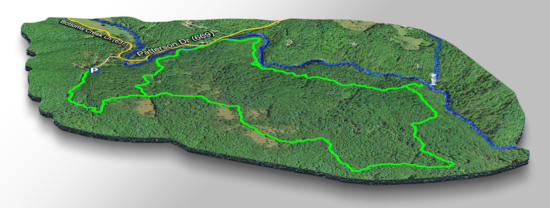
3D Trail Map – Bent Mountain Falls
⚠️ Important:
There is no access to the base of the waterfall. The best views are from designated overlooks along the trail.
🥾 What the Trail is Like
The trail begins gradually before descending into Bottom Creek Gorge. Along the way, you’ll encounter:
- Forest canopy
- Moss-covered rocks and a stream
- Scenic ridge views
- Quiet, well-maintained paths
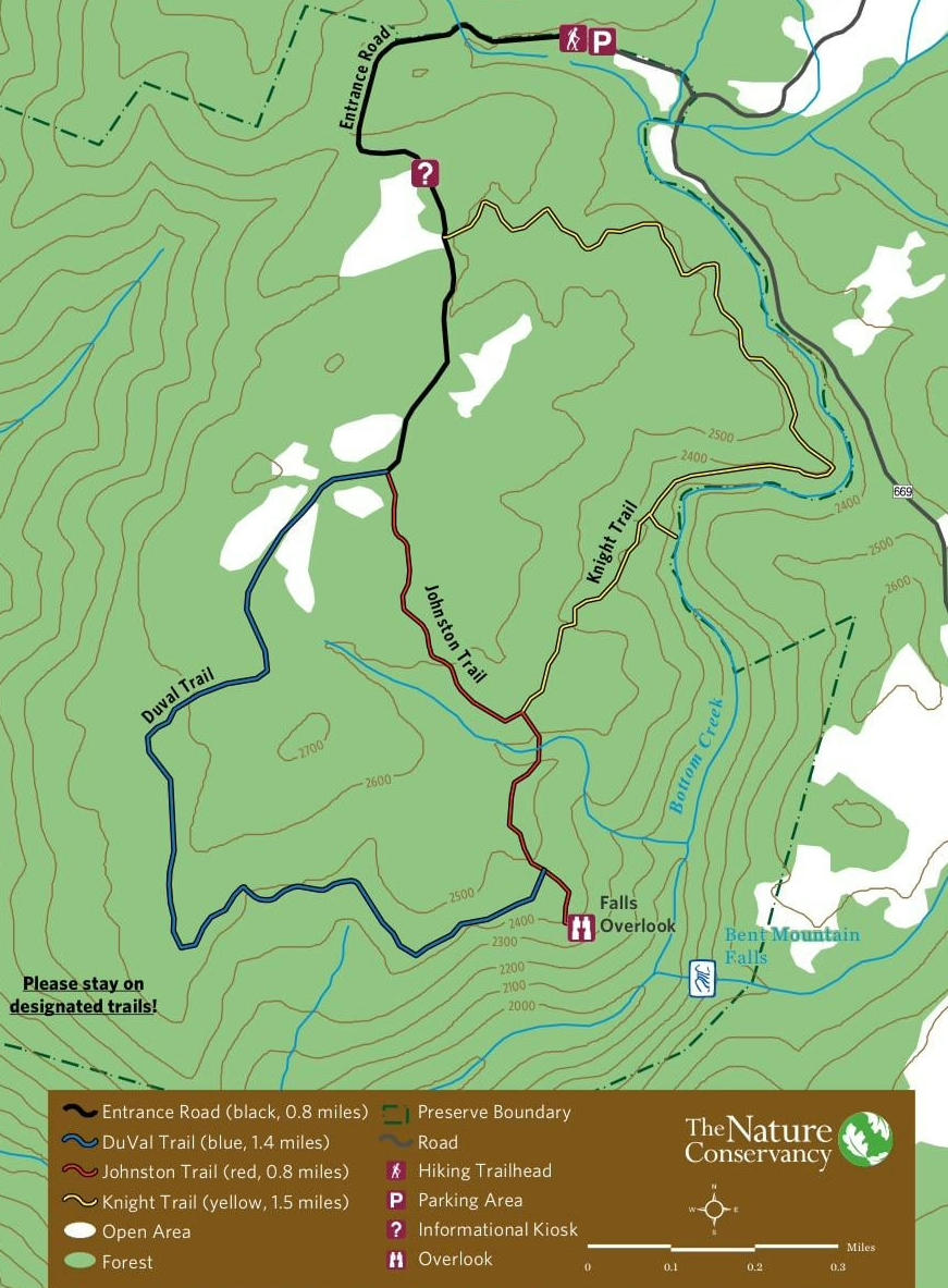
You walk a short distance until you reach the information board, where you will be introduced to the three trail options – red, yellow, or blue. We prefer the outer loop (Red – Yellow – Blue) to see the actual Bottom Creek and to see some of the other sights as explained on the information board.
Bent Mountain Falls Trail Profile
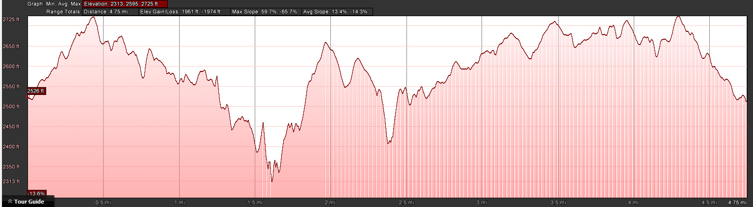
It is 1.6 miles from the parking lot to the Creek and 2.4 miles to the Falls Viewpoint when using the Yellow Trail.
As you approach the overlook, the sound of falling water grows louder, revealing a dramatic drop framed by cliffs and forested slopes.
While the waterfall is not directly accessible, the elevated vantage point offers a remote and slightly obscured view—especially after rainfall or during spring runoff.

🌸 Best Time to Visit Bent Mountain Falls
Spring (March–May)
✅ Best water flow
✅ Wildflowers
⚠️ Muddy trails possible
Summer (June–August)
✅ Lush greenery
⚠️ Humid, lower water levels
Fall (September–November)
🍁 Stunning foliage
🍂 Cooler temperatures
📸 Best photography season
Winter
⚠️ Trails may be icy
⚠️ Limited access after snow
👉 For the best experience, visit in late spring or mid-fall.
🎒 What to Bring
- Sturdy hiking shoes (rocky sections)
- Water (no sources on trail)
- Bug spray (warm months)
- Camera or phone for photos
- Offline map or GPS
- Light jacket (weather changes quickly)
Please read our “Safety Kit For Waterfall Hiking in Virginia” article.
⚠️ Safety & Trail Tips
- Stay on marked trails — steep drop-offs exist
- Do not attempt to climb down to the falls
- Leave No Trace
- Black bear presence. Stay vigilant
- Check weather before hiking
- Start early to avoid afternoon heat
🏞️ Nearby Places to Explore
If you’re building a waterfall road trip or exploring the Blue Ridge region, consider pairing this hike with:
- Roanoke
- Blue Ridge Parkway overlooks
- Stiles Falls
👉 This area works beautifully as part of a multi-day Virginia waterfall itinerary.
❓ Frequently Asked Questions
How long is the Bent Mountain Falls hike?
The loop is approximately 4.8 miles and takes 2–3 hours depending on pace and trail choices.
Is Bent Mountain Falls easy to hike?
It’s considered moderate, with elevation gain and uneven terrain.
Can you swim at Bent Mountain Falls?
No. There is no safe access to the base of the waterfall, but you can swim in the creek along the Yellow Trail.
Are dogs allowed?
No. Pets are not permitted in Bottom Creek Gorge Preserve.
Is Bent Mountain Falls worth visiting?
Absolutely — especially if you enjoy quiet trails, scenic overlooks, and uncrowded hikes.
🌄 Final Thoughts
Bent Mountain Falls is difficult to photograph, and it is not a touristy waterfall—and that’s exactly its charm.
It’s a place for reflection, slow travel, and immersion in Virginia’s rugged beauty. Whether you’re building a waterfall road trip, exploring the Blue Ridge Mountains, or simply looking for a peaceful hike, this trail delivers an unforgettable experience.
If you’re drawn to journeys that combine nature, movement, and meaning, Bent Mountain Falls belongs on your list.
Google Map of Virginia Waterfalls
Bent Mountain Falls is near Bent Mountain on this Virginia Waterfalls map by Eben Schoeman.